Digital Prepping, Part 1 - Off-Line Websites & Maps
The first step in making your computer usable when the Internet goes away. Because it will.
This is Part 1 in a series of articles on “Digital Prepping” — preparing your computers and smartphones for the possibility of any number of events… which could leave you without Internet or power for an extended period of time.
The Internet is an amazing tool, to be sure — an always connected network which we can use to look up nearly any piece of information we might think of.
Historical tidbits, recipes, maps, technical engineering details, how-to’s, song lyrics… you name it.
But what happens… when that “always connected network”… is no longer always connected?
What if, for whatever reason, you are left without Internet access for an hour? A day? A month? Or, dare I even say it, what if the Internet is simply… gone forever?
These are not far-fetched notions.
The Internet has only existed for a short period of time — there is no reason to believe it will continue to exist indefinitely.
There are regular Internet outages all across the world, with some impacting large areas.
And, let’s face it, the Internet infrastructure is darned fragile — with huge numbers of critical points of failure.
Plus… There are areas you may travel to where you simply will not have Internet access. Or, heck, you might not want Internet access for some reason.
In other words: How do you get access to all of that information… when you cannot access the Internet?
Luckily… it’s pretty darned easy. You’ll just need to plan ahead a little bit.
Off-Line Websites
The first — and possibly the easiest — thing you can do is to grab an “Off-Line Web Browser”. Which is exactly what it sounds like: an application that lets you use websites — which you have pre-downloaded — when you have no Internet connection.
There are multiple options available but, for now, I recommend starting with Kiwix. Which, as luck would have it, is available for nearly every major computing platform you can think of (Windows, Mac, Linux, Android, and iOS).
Kiwix works by loading a website archive file format known as a ZIM file — which, essentially, takes a whole website… and sticks it into a single, searchable file for your use when Off-Line.
Once installed, you can then proceed to download any of a number of website archives that have been pre-created — on a huge range of topics. Including archives of Stack Exchange Q&A’s, Wikipedia, Project Gutenberg, cooking & prepping resources, and so much more.
Those .ZIM website archives can be downloaded both from the website, as well as directly from within the Kiwix application, itself. Extremely easy to use, no account necessary, and it runs almost anywhere.
Once downloaded, you can use Kiwix almost like any normal web browser. Except it’s not connected to the Internet.
Depending on how many websites you’ll want full archives of, this can take up quite a large amount of space. The full archive of Wikipedia, for example, is 89 GB in size (luckily they’ve also broken that down into categories if there are only a few topics that interest you).
Want all of Wikipedia, Stack Overflow, Project Gutenberg (which gives you over 60,000 eBooks, including a huge number of classics), and the full archive of wikiHow (because instructional articles are handy)? You’re going to need several hundred GB of storage ready (and, hopefully, a pretty fast Internet connection to grab them all).
Luckily, once downloaded, those .ZIM archives can be backed up, copied around, and re-used on any device.
Off-Line Maps
There was a time when all maps were “Off-Line”. They came on paper, and every car had a collection of them in the glove compartment. And everyone had a road atlas (at least one covering the area they lived).
Nowadays? Almost everyone has become reliant on services like Google Maps to find their way around.
Loose access to the Internet? This can become a big problem in a hurry.
Luckily we have solutions.
The first, and most simple, solution is to use the “Off-Line Maps” feature of Google Maps. This allows you to download a large portion of the location data for an area that you select. You will then be able to use Google Maps (somewhat) regularly for that region.
This is handy. And, if you use Google Maps, I highly recommend doing this for at least the area where you live. It truly does work pretty well.
However: There are some serious downsides to this mechanism.
Your “Off-Line” map is not going to be available to you on all of your computers and smartphones.
It is only going to function as long as Google’s software allows it to function. And, since that software is all closed (and typically reliant on an Internet connection), we have no idea how long that will truly be.
It assumes you can (or want to) use Google Maps.
Which means: You’re going to want another solution as well.
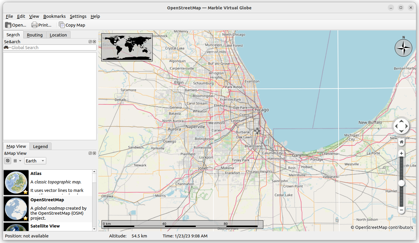
My personal recommendation: OpenStreetMap.
OpenStreetMap is a free — volunteer built — map database which, in my experience, is extraordinarily complete. You will, on occasion, find gaps in information… but usually only for the most remote areas.
There are a large number of applications, for a number of platforms, that can utilize OpenStreetMap data while Off-Line. But, for my money, the best available is Marble.
Marble is available for Linux, Windows, Mac, and Android… and has an absolutely huge number of features. Including the ability to download sections of a map, or download entire map databases — including modern maps, satellite views, and a wide range of historical maps and globes dating back hundreds of years.
All of this makes Marble not only an excellent choice for modern mapping and driving/walking direction needs… but also for educational and historical purposes.
Note: If you have trouble running Marble on recent versions of Android, there are several OpenStreetMap applications available for mobile platforms (including OsmAnd).
This is just scratching the surface
As you begin your “Digital Prepping” journey, you’re going to quickly realize just how much of your day-to-day computing is utterly reliant on an active Internet connection (or, at the very least, an occasional connection).
Music, language translations, software installations and updating, operating system setup, communication… the list goes on-and-on.
What we’ve done here, today, is the first step towards preparing yourself for a complete and total loss of Internet connectivity — an eventuality that is all but certain to occur (even if just for a short period).
As we continue through this series of articles, we will also be touching on some other aspects of “Digital Prepping” that are a bit more… let’s just say… intense.
Computing when there is no electrical power grid.
Creating your own “Mini Internet”.
Short, medium, and long range data transmission.
Preparing for EMPs (electromagnetic pulse), floods, fires, and other physical threats to computers and data.
Effective and safe backups of critical data on physical media.
Your Homework for Part 1
It’s one thing to know these options are available for having access to information Off-Line… it’s another to put it into practice.
With that in mind… I’ve got some homework for you. Nothing difficult… should take no more than a few minutes, at most. But, when you’re done, you’ll have taken your first steps towards becoming a true Digital Prepper.
Install both Marble and Kiwix on one device. The links are above.
Launch Kiwix and download one website archive that interests you.
Launch Marble, select “Open Street Map”, zoom in to the town you live. Select the File Menu, and click “Download Region” to make an Off-Line copy of that map area.
Shazam! You now have your local area mapped for when the Internet goes down… and something to read!
See you in Part 2 of “Digital Prepping”… where we will prepare your Operating System for being completely Off-Line (including installation, drivers, updates, and installing new software).
Be sure to grab a subscription to The Lunduke Journal of Technology, so you don’t miss out on future Digital Prepping articles.
Lunduke Journal of Technology Monthly PDF - Exclusive Videos & Books - Subscriptions
Some other Premium Lunduke Journal Articles you might enjoy:
Lunduke.Locals.com - Lunduke on Twitter - Lunduke on LinkedIn


Another offline map solution (also built from OSM data) is this ~1 GB Kiwix ZIM file on Gumroad - https://anthonykaram.gumroad.com/l/offline_world_map
Just try mapy.cz for Android. Offline maps, offline navigation, recording tracks... Available with OSM and has tourist and cycle maps.